
Resource Classification Optimization: Automatic Category Smoothing with Leapfrog and Asturmine
Asturmine automates the critical process of category smoothing using Indicator Numerical Models in Leapfrog Geo, eliminating subjectivity and drastically reducing technical team times.
Eliminated manual editing of wireframes and polylines section by section
Generated consistent, reproducible, and subjectivity-free envelopes
Guaranteed logical progression of categories under JORC and NI 43-101 standards
Allowed dynamic updates of smoothing when new drilling data is available
1. Context: The importance of smoothing in resource classification
In mineral resource estimation, assigning categories (measured, indicated, and inferred) is a standard practice regulated by international codes such as JORC or NI 43-101. This classification reflects the degree of geological and technical confidence in the continuity and quality of the resource, having direct implications on planning decisions, economic evaluations, and feasibility studies.
However, when applying strict quantitative criteria (such as number of samples, slope of regression, average distance, etc.), it is common for the generated models to exhibit a highly fragmented spatial distribution. This leads to geologically inconsistent situations, such as isolated measured blocks within inferred zones, or mosaic structures that do not correspond to a realistic geological interpretation.
Resource category smoothing thus emerges as a fundamental tool to improve spatial consistency, facilitate model communication, avoid misinterpretations in mine planning, and ensure the technical robustness of the final report. This practice also aligns with the recommendations of multiple Competent Persons and technical auditors, who demand a critical mass and minimum continuity for each resource category.
2. Problem: Limitations of traditional manual smoothing
The most common procedure for smoothing resource categories consists of manually editing wireframes or polylines in each section or plan view of the model, reclassifying blocks based on their immediate surroundings. Although effective in some contexts, this method has significant limitations:
- High workload: Requires hours of intensive work by the modeler, especially in deposits with complex geometries or multiple domains.
- Unnecessary repetition: Every time block models are updated due to new drilling data or changes in estimation parameters, the entire smoothing process must be redone from scratch.
- Subjectivity and arbitrariness: Depending on manual interpretation, the classification can vary between different sections or modelers, introducing biases and a loss of reproducibility.
- Limited scalability: In large mining operations or multi-year campaigns, maintaining smoothing consistency over time becomes almost unfeasible.
As a result, many models end up reporting unrealistic categorizations or are forced to maintain 'broken' zones simply due to a lack of time or resources to apply comprehensive smoothing.
3. Solution: Asturmine's Automated Methodology with Leapfrog Indicator Models
Faced with the limitations of traditional manual smoothing, Asturmine has developed an automated methodology for resource category smoothing based on the use of Indicator Numerical Models (INM) within Seequent's Leapfrog Geo platform. This methodology enables the generation of consistent, reproducible, and updatable wireframes for measured and indicated resource domains, eliminating subjectivity and significantly reducing labor times.
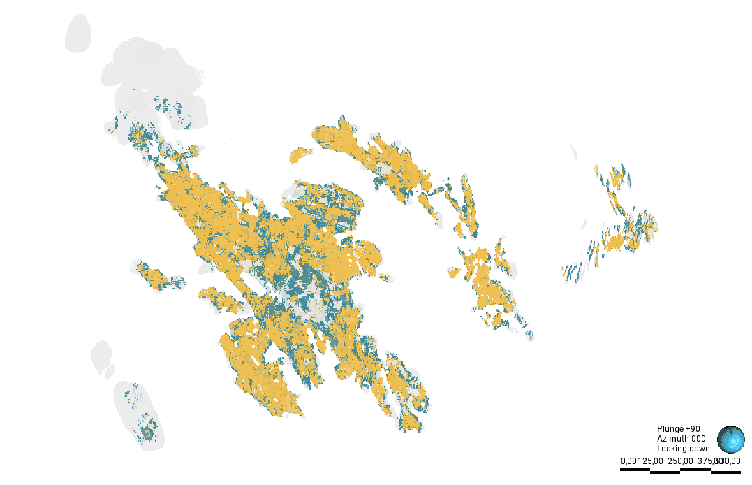
Fig 1: Unsmoothed model
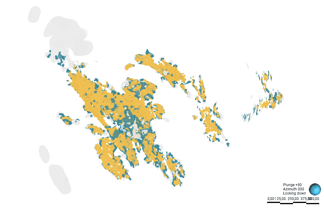
Fig 2: Smoothed model
Principles of the Method
1. Generation of binary columns from mathematical RESCAT
The process starts from a numerical classification field of the block model, generated during resource estimation (for example, a column like RESCAT_MATH where values 1, 2, and 3 indicate measured, indicated, and inferred blocks, respectively). From this field:
- The block model filtered by mineral material (e.g., 'Ore') is exported, including only the mathematical classification column.
- It is imported as a points file into Leapfrog Geo, ensuring that the field is recognized as numerical and not categorical, since INM models require numerical fields to operate.
Once imported, two new columns are created to act as binary indicators:
- INM_Measured: Value 1 if the block is measured. Value 0 in any other case.
- INM_Indicated: Value 1 if the block is measured or indicated. Value 0 if it is inferred.
These two columns will be used as the basis to generate two independent INM models.
2. Configuration of the indicator numerical model parameters
Two INM models are built, one for each category:
- INM_Measured: delimits model zones with binary classification 1 for measured blocks.
- INM_Indicated: delimits the joint envelope of measured and indicated blocks.
The critical INM parameters to configure are:
- Surface Resolution: Determines the level of detail of the resulting wireframe. A higher resolution generates models that fit tighter to the point cloud, while larger numerical values smooth the contour more.
- Isovalue: Defines the model threshold to consider a point as part of the domain. A low value (e.g., 0.25) tends to expand the domain, incorporating less connected points and generating larger envelopes. A high value (e.g., 0.75) generates a more restricted and selective domain, resulting in smaller envelopes.
- Interpolation function: The spheroidal function must be used, which requires: Definition of the interpolation range: This range determines the volume of influence of each point and, therefore, controls how many blocks must be grouped to generate a continuous envelope. High range = greater smoothing, fewer 'islands'. Low range = greater detail, but greater risk of internal fragmentation.
- Volume Filter: A key tool for removing small residual volumes (artifacts) that might appear within larger domains. This step refina the final result, eliminating elements that do not add geological meaning.
The optimal configuration of these parameters will depend on the deposit style, drillhole spacing, and the model's objective (economic studies, mine planning, etc.).
3. Grouping and final model evaluation
Once the two INM models are generated, a combined Grouped Mesh is created, grouping the inside volumes of both INMs, giving hierarchical preference to the measured volume. This grouping is evaluated directly on the original block model, updating the smoothed classification column (RESCAT_INM).
This allows obtaining a new category classification field that is much more spatially consistent, ready for reporting, planning, or auditing.
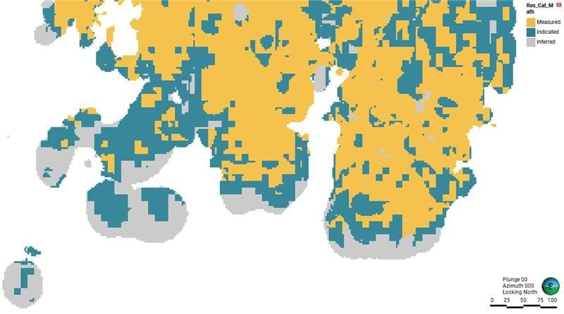
Fig 3. Unsmoothed model.
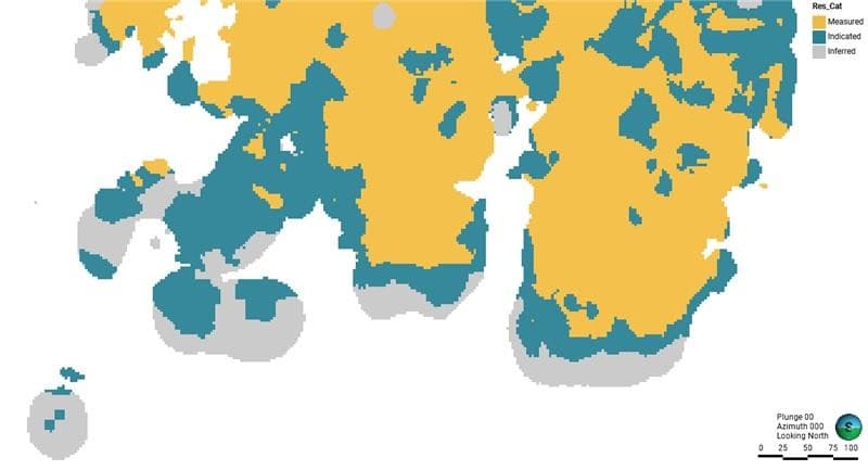
Fig 4. Smoothed model.
Optional extension: smoothing transitions between measured and inferred
In some models, even after applying the INM, direct contacts between measured and inferred blocks may persist without the presence of intermediate indicated blocks. This situation contradicts the principle of progressivity in resource confidence (measured → indicated → inferred), especially in reports following JORC standards.
To avoid this, Asturmine proposes an extension to the method:
- A buffer is generated around the measured volume using the New Distance Factor tool in Leapfrog.
- This buffer, with a configurable thickness (e.g., 10 meters), intersects with the inferred blocks and can be reclassified as an indicated zone or maintained as a transition zone.
- The result is a model in which a progressive separation of categories is guaranteed, respecting the logic of the geological model and resource classification standards.
Conclusions
Resource category smoothing no longer has to be a manual, slow, and subjective task. Thanks to its innovative and rigorous approach, Asturmine automates this critical process, elevating model quality and optimizing technical team resources. This methodology not only improves model presentation but also reinforces the technical soundness of the report, transparency for auditors, and confidence in strategic decision-making.
Asturmine continues to develop solutions that combine science, technology, and efficiency at the service of the modern mining industry.